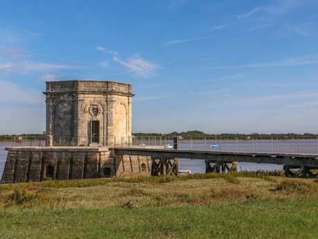
rochefort-ocean-st-nazaire-sur-charente-fontaine-lupin © Caroline Jarry.jpg

Walking route: La Saint-Nazairienne - 7.5 mi

in Saint-Nazaire-sur-Charente
11.9 km
  • The countryside around Saint-Nazaire has so much to offer! Whether you’re walking through the fields or along the estuary past the Lupin fountain, you’ll encounter a variety of scenery along the way.


  • Along your route, you will pass through:

    - Saint-Nazaire-sur-Charente: which formed part of the seigneury of Soubise, of which it was the most populous parish. On the shores of the Gulf of Saintonge, it occupied the entire southern tip of the Charente estuary, a strategic site facing the Fouras peninsula.

    You will spot:

    - The green and yellow grass snake: this black snake, speckled with yellow, is very common. Like all grass snakes in the region, it is non-venomous and plays a vital...
    Along your route, you will pass through:

    - Saint-Nazaire-sur-Charente: which formed part of the seigneury of Soubise, of which it was the most populous parish. On the shores of the Gulf of Saintonge, it occupied the entire southern tip of the Charente estuary, a strategic site facing the Fouras peninsula.

    You will spot:

    - The green and yellow grass snake: this black snake, speckled with yellow, is very common. Like all grass snakes in the region, it is non-venomous and plays a vital role in the balance of ecosystems and the food chain, feeding mainly on small mammals (mice). Like all reptiles, it is protected at national level.
  • Difference in height
    64.85 m
  • Documentation
    GPX / KML files allow you to export the trail of your hike to your GPS (or other navigation tool)
Points of interest
65 meters of difference in height
  • Start altitude : 14 m
  • End altitude : 15 m
  • Maximum altitude : 17 m
  • Minimum altitude : 1 m
  • Total positive elevation : 65 m
  • Total negative elevation : -64 m
  • Max positive elevation : 10 m
  • Min positive elevation : -7 m