See photos (2)
Walking route: Marais du Transbordeur - 2.5mi
in Rochefort
4.1
km
1h
Easy
-
Opposite the Transbordeur Bridge, explore the southern marshes of Rochefort and all they have to offer. Once you’ve passed the wastewater treatment plant, follow the major cycle routes: the Vélodyssée® and the Flow vélo®.
-
Opposite the Transbordeur Bridge, explore the southern marshes of Rochefort and all they have to offer. Once you’ve passed the wastewater treatment plant, follow the major cycle routes: the Vélodyssée® and the Flow vélo®.
Along the way, you’ll see:
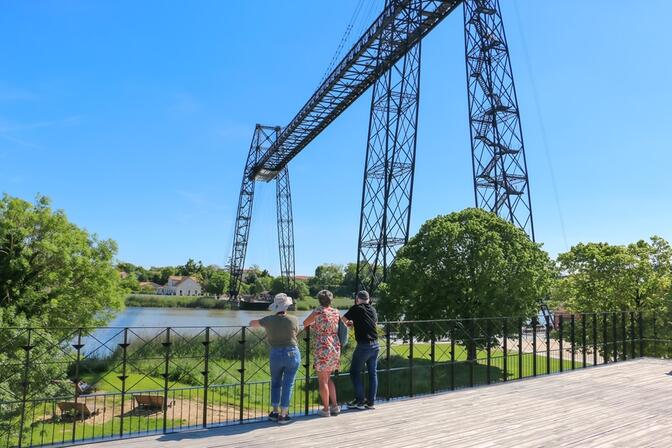
- The Transbordeur Bridge: built in 1900 and the last structure of its kind in France, this suspension bridge with a gondola – listed as a Historic Monument and reserved for non-motorised transport – takes you across the Charente, offering...Opposite the Transbordeur Bridge, explore the southern marshes of Rochefort and all they have to offer. Once you’ve passed the wastewater treatment plant, follow the major cycle routes: the Vélodyssée® and the Flow vélo®.
Along the way, you’ll see:
- The Transbordeur Bridge: built in 1900 and the last structure of its kind in France, this suspension bridge with a gondola – listed as a Historic Monument and reserved for non-motorised transport – takes you across the Charente, offering breathtaking views of the estuary and the surrounding countryside. A unique experience to enjoy after your walk between April and the end of October!
You will pass through:
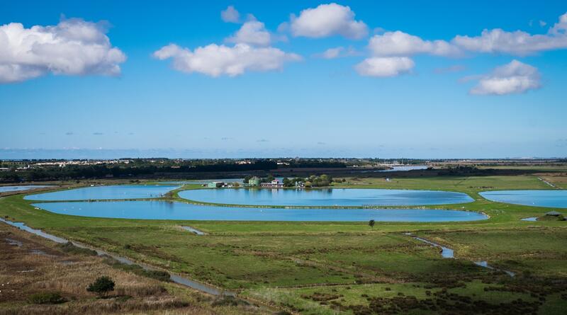
- The lagooning treatment plant: The lagooning technique treats all the town’s wastewater using the natural principle of eco-purification in vast bodies of water
(35 hectares) through the combined action of the sun, wind and micro-organisms. A key benefit of this eco-friendly technique is that it promotes the growth of plankton, an ideal food source for many waterbirds (160 species are regularly observed). The plant is an ‘Échappées Nature’ accredited site (part of the Charente-Maritime network of Sensitive Natural Areas).
- The Transbordeur Marsh: Covering 600 hectares on the outskirts of Rochefort, with 80 kilometres of ditches, it acts as a buffer zone between the town and the River Charente, harbouring a wealth of biodiversity. Livestock farming is essential here for the maintenance of the wet meadows and this open landscape. Here you can find the sea iris (dark purple), the umbellate cattail, and the flowering rush with its small pink flowers, which bloom late in the season (July).
- Difference in height
- 19.93 m
-
-
Documentation
- GPX / KML files allow you to export the trail of your hike to your GPS (or other navigation tool)
-
- See all reviews
- Points of interest
1
Transporter Bridge
The arch of the Grand Site de l'Estuaire de la Charente – Arsenal de Rochefort is a masterpiece of metal architecture and the last structure of its kind in France.
The gondola suspended above the water allows pedestrians and cyclists to cross between Rochefort and Échillais. Listed as a Historic Monument, the Transporter Bridge and seven others around the world are hoping to be included one day in the UNESCO World Heritage List.
Discover its history at the interpretation centre, the Maison du Transbordeur on the Échillais bank (free admission).
Visit the souvenir shop at the Rochefort reception centre, which now features a panoramic terrace offering breathtaking views of the bridge.
Ticket offices are located at the foot of the bridge on the Rochefort side and at the Maison du Transbordeur on the Échillais side.
Crossings take place every 10 to 15 minutes, subject to good technical and weather conditions. The last crossing will take place 15 minutes before closing time.
2
Lagoon treatment plant
The site is managed both by the Community of Agglomeration of Rochefort Océan (CARO) and the League for the Protection of Birds (LPB)
- 20 meters of difference in height
-
- Start altitude : 3 m
- End altitude : 3 m
- Maximum altitude : 5 m
- Minimum altitude : 1 m
- Total positive elevation : 20 m
- Total negative elevation : -20 m
- Max positive elevation : 1 m
- Min positive elevation : -2 m
